- March 19, 2026
- admini
- 0
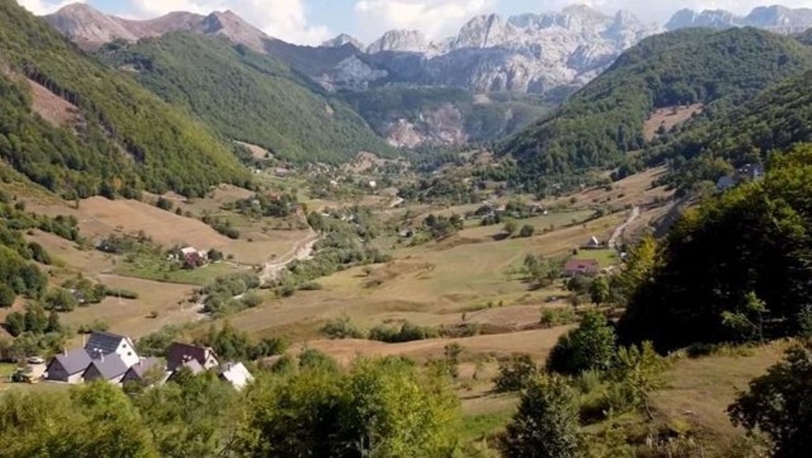
The Council of Ministers decided this Thursday to declare several areas in the territory of the municipalities of Berat, Dimal, Durrës, Himarë, Kavajë, Librazhd, Mirditë, Rrogozhinë and Vlorë as “Priority Areas for the Development of the Mountain Economy”.
The Minister of State for Local Government, Ervin Demo, stated during a press conference that the number of applications for the Mountain Package has reached 400. Demo stated that the objective of reaching 1,000 applications by the end of 2026 is feasible.
Council of Ministers:
DECISION ON THE DECLARATION OF SOME AREAS WITH PRIORITY FOR THE DEVELOPMENT OF THE MOUNTAIN ECONOMY IN THE MUNICIPALITY OF BERAT
In support of Article 100 of the Constitution and point 1, Article 4, of Law No. 20/2025, “On the Mountains Package”, with the proposal of the Minister of State for Local Government, the Council of Ministers
DECISION:
I. The declaration of “Areas with priority for the development of the mountain economy” of several areas in the territory of the Municipality of Berat, as follows:
1. Area No. 1, Balibardhë village, part of the administrative unit Otllak, Municipality of Berat, Berat District, with an area of 14.09 (fourteen point zero nine) ha, according to the map in the KRGJSH system;
2. Zone no. 2, Balibardhë village, part of the Otllak administrative unit, Berat Municipality, Berat District, with an area of 22.61 (twenty-two point sixty-one) ha, according to the map in the KRGJSH system;
3. Zone no. 3, Balibardhë village, part of the Otllak administrative unit, Berat Municipality, Berat District, with an area of 91.84 (ninety-one point eighty-four) ha, according to the map in the KRGJSH system;
4. Zone no. 4, Balibardhë village, part of the Otllak administrative unit, Berat Municipality, Berat District, with an area of 16.2 (sixteen point two) ha, according to the map in the KRGJSH system;
5. Zone no. 5, Bilçë village, part of the Velabisht administrative unit, Berat Municipality, Berat District, with an area of 299.06 (two hundred ninety-nine point zero six) ha, according to the map in the KRGJSH system;
6. Zone no. 6, Malinat village, part of the Velabisht administrative unit, Berat Municipality, Berat District, with an area of 4.09 (four point zero nine) ha, according to the map in the KRGJSH system;
7. Zone no. 7, Malinat village, part of the Velabisht administrative unit, Berat Municipality, Berat District, with an area of 10.51 (ten point fifty-one) ha, according to the map in the KRGJSH system;
8. Zone no. 8, Malinat village, part of the Velabisht administrative unit, Berat Municipality, Berat District, with an area of 13.67 (thirteen point sixty-seven) ha, according to the map in the KRGJSH system;
9. Area no. 9, Malinat village, part of the Velabisht administrative unit, Berat Municipality, Berat District, with an area of 5.53 (five point fifty-three) ha, according to the map in the KRGJSH system;
10. Area no. 10, Malinat village, part of the Velabisht administrative unit, Berat Municipality, Berat District, with an area of 5.12 (five point twelve) ha, according to the map in the KRGJSH system;
11. Area no. 11, Malinat village, part of the Velabisht administrative unit, Berat Municipality, Berat District, with an area of 7.22 (seven point twenty-two) ha, according to the map in the KRGJSH system;
12. Area no. 12, Malinat village, part of the Velabisht administrative unit, Berat Municipality, Berat District, with an area of 7.01 (seven point zero one) ha, according to the map in the KRGJSH system;
13. Area no. 13, Malinat village, part of the Velabisht administrative unit, Berat Municipality, Berat District, with an area of 3.84 (three point eighty-four) ha, according to the map in the KRGJSH system;
14. Area no. 14, Malinat village, part of the Velabisht administrative unit, Berat Municipality, Berat District, with an area of 3.22 (three point twenty-two) ha, according to the map in the KRGJSH system;
15. Area no. 15, Palikësht village, part of the Velabisht administrative unit, Berat Municipality, Berat District, with an area of 48.98 (forty-eight point ninety-eight) ha, according to the map in the KRGJSH system;
16. Zone no. 16, Qereshnik village, part of the Otllak administrative unit, Berat Municipality, Berat District, with an area of 74.97 (seventy-four point ninety-seven) ha, according to the map in the KRGJSH system;
17. Zone no. 17, Qereshnik village, part of the Otllak administrative unit, Berat Municipality, Berat District, with an area of 87.69 (eighty-seven point sixty-nine) ha, according to the map in the KRGJSH system;
18. Zone no. 18, Qereshnik village, part of the Otllak administrative unit, Berat Municipality, Berat District, with an area of 90.13 (ninety-three point thirteen) ha, according to the map in the KRGJSH system;
19. Zone no. 19, Ullinjas village, part of the Otllak administrative unit, Berat Municipality, Berat District, with an area of 13.85 (thirteen point eighty-five) ha, according to the map in the KRGJSH system;
20. Zone no. 20, Ullinjas village, part of the Otllak administrative unit, Berat Municipality, Berat District, with an area of 5.76 (five point seventy-six) ha, according to the map in the KRGJSH system;
21. Zone no. 21, Ullinjas village, part of the Otllak administrative unit, Berat Municipality, Berat District, with an area of 0.48 (zero point forty-eight) ha, according to the map in the KRGJSH system;
22. Zone no. 22, Veleshnjë village, part of the Velabisht administrative unit, Berat Municipality, Berat District, with an area of 8.35 (eight point thirty-five), ha, according to the map in the KRGJSH system;
23. Zone no. 23, Veleshnjë village, part of the Velabisht administrative unit, Berat Municipality, Berat District, with an area of 5.04 (five point zero four) ha, according to the map in the KRGJSH system;
24. Area no. 24, Veleshnjë village, part of the Velabisht administrative unit, Berat Municipality, Berat District, with an area of 20.78 (twenty point seventy-eight) ha, according to the map in the KRGJSH system;
25. Area no. 25, Veleshnjë village, part of the Velabisht administrative unit, Berat Municipality, Berat District, with an area of 12.66 (twelve point sixty-six) ha, according to the map in the KRGJSH system;
26. Area no. 26, Veleshnjë village, part of the Velabisht administrative unit, Berat Municipality, Berat District, with an area of 2.8 (two point eight) ha, according to the map in the KRGJSH system;
27. Area no. 27, village Mbjeshovë, part of the administrative unit Sinjë, Municipality of Berat, Berat District, with an area of 15.3 (fifteen point three) ha, according to the map in the KRGJSH system;
28. Area no. 28, village Lapardha 2, part of the administrative unit Otllak, Municipality of Berat, Berat District, with an area of 15.98 (fifteen point ninety-eight) ha, according to the map in the KRGJSH system;
29. Area no. 29, village Roshnik Qendër, part of the administrative unit Roshnik, Municipality of Berat, Berat District, with an area of 1.98 (one point ninety-eight) ha, according to the map in the KRGJSH system;
30. Area no. 30, Roshnik Qendër village, part of the Roshnik administrative unit, Berat Municipality, Berat District, with an area of 2.92 (two point ninety-two) ha, according to the map in the KRGJSH system;
31. Area no. 31, Karkanjoz village, part of the Roshnik administrative unit, Berat Municipality, Berat District, with an area of 0.45 (zero point forty-five) ha, according to the map in the KRGJSH system;
32. Area no. 32, Karkanjoz village, part of the Roshnik administrative unit, Berat Municipality, Berat District, with an area of 11.1 (eleven point one) ha, according to the map in the KRGJSH system;
33. Area no. 33, Karkanjoz village, part of the Roshnik administrative unit, Berat Municipality, Berat District, with an area of 8.84 (eight point eighty-four) ha, according to the map in the KRGJSH system;
34. Area no. 34, Qafë-Dardhe village, part of the Roshnik administrative unit, Berat Municipality, Berat District, with an area of 34.06 (thirty-four point zero six) ha, according to the map in the KRGJSH system;
35. Area no. 35, Qafë-Dardhe village, part of the Roshnik administrative unit, Berat Municipality, Berat District, with an area of 55.4 (fifty-five point four) ha, according to the map in the KRGJSH system;
36. Area no. 36, Qafë-Dardhe village, part of the Roshnik administrative unit, Berat Municipality, Berat District, with an area of 0.93 (zero point ninety-three) ha, according to the map in the KRGJSH system;
37. Area no. 37, village Qafë-Dardhe, part of the administrative unit Roshnik, Municipality of Berat, Berat District, with an area of 2.29 (two point twenty-nine) ha, according to the map in the KRGJSH system;
38. Area no. 38, village Roshnik Qendër, part of the administrative unit Roshnik, Municipality of Berat, Berat District, with an area of 9.56 (nine point fifty-six) ha, according to the map in the KRGJSH system;
39. Area no. 39, village Mbreshtan, part of the administrative unit Sinjë, Municipality of Berat, Berat District, with an area of 11.03 (eleven point zero three) ha, according to the map in the KRGJSH system;
40. Area no. 40, Paftal village, part of the Sinjë administrative unit, Berat Municipality, Berat District, with an area of 73.87 (seventy-three point eighty-seven) ha, according to the map in the KRGJSH system;
41. Area no. 41, Sinjë village, part of the Sinjë administrative unit, Berat Municipality, Berat District, with an area of 9.05 (nine point zero five) ha, according to the map in the KRGJSH system;
42. Area no. 42, Sinjë village, part of the Sinjë administrative unit, Berat Municipality, Berat District, with an area of 15.22 (fifteen point twenty-two) ha, according to the map in the KRGJSH system;
43. Area no. 43, Sinjë village, part of the Sinjë administrative unit, Berat Municipality, Berat District, with an area of 13 (thirteen) ha, according to the map in the KRGJSH system;
44. Zone no. 44, Sinjë village, part of the Sinjë administrative unit, Berat Municipality, Berat District, with an area of 3.69 (three point sixty-nine) ha, according to the map in the KRGJSH system.
II. The extent, boundaries and entry and exit points of these zones are determined on the indicative map according to the KRGJSH system, which is attached to this decision.
III. The types of activities that will be developed in these zones are:
1. economic development;
2. industrial development;
3. tourist development.
IV. The Ministry of Economy and Innovation, the State Cadastre Agency and the Municipality of Berat are charged with the implementation of this decision.
This decision shall enter into force upon publication in the “Official Gazette”.